Record Detail
Large format version available - click on Zoom button to browse this image in a zoomable viewer
| q00037 | |
| Ordnance Survey Map, sheet no. Yorkshire No. 294.3.25 | |
| Sheffield_Neepsend | |
| 1889 | |
| 1851-1899 | |
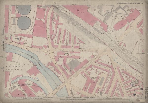
Surveyed 1889. Reprinted 1891 This map features: Top left: Neepsend Gas Works, Hallamshire Works [Hallamshire Steel and File Company], Bardwell Street, Manchester, Sheffield and Lincolnshire Railway, Neepsend Lane, Neepsend Tavern, Cook Street, Boyland Place, Boyland Street, Engine Shed, River Don, Gasometer (x2),Prince of Wales Public House. Top right: Manchester, Sheffield and Lincolnshire Railway, Boyland Street, Engine Shed, Rutland Road, Corporation Yard, Neepsend Brick Works, Rutland Street, Stone Yard. Bottom left: River Don, Neepsend Lane, Rutland Road, Cannon Brewery, Burton Road, Philadelphia Steel Works [possibly William and Samuel Butcher], Bacon Island, Rutland Works [Samuel Osborn and Co. Limited], Neepsend Bridge, School [Neepsend National School],Playground,Corn Inn, Artisan works, Rutland Hotel Public House, Timber Yard. Bottom right: Manchester, Sheffield and Lincolnshire Railway, Rutland Road, Cannon Brewery, Burton Road, Rutland Terrace, Hicks Street, Bury Street, Burton Road Brewery [Strouts Brewery Co.], Haddon Street, Percy Street, Rutland Square, Bingley Street, Vicarage [St Michael’s and All Angels, Neepsend], Smithy, Corporation Yard, Timber Yard, Platt Street, Timber Yard. Dimensions 77 x 102 cm. Scale 10.56 feet : 1 mile [1:500]. Original at Sheffield City Archives. |
Copying and access
This digital image, and all images on Picture Sheffield, are protected by copyright. You may use it for private study or non-commercial research, with due acknowledgement.
You may share it on social media via a linked post or by citing www.picturesheffield.com together with the Image Reference, unless its copyright is noted as belonging to another organisation. You must not reproduce it by any other means without permission.