Place the cursor on an image to see its title. Click to enlarge and obtain more information.
Click on add to album to keep a working record of the images you are interested in |
Place the cursor on an image to see its title. Click to enlarge and obtain more information.
Click on add to album to keep a working record of the images you are interested in |
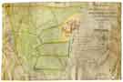
![View: arc03405 A plan of the field between the tail goit of the Lead Mill and the Corn Mill dam, with additions to be made to the tail goit, [18th cent]](https://www.picturesheffield.com/imagefiles/jpgs_sheffield3//arc03405.jpg)


;)
;)
;)
;)
;)
;)
;)
;)
;)
;)