Place the cursor on an image to see its title. Click to enlarge and obtain more information.
Click on add to album to keep a working record of the images you are interested in |
Place the cursor on an image to see its title. Click to enlarge and obtain more information.
Click on add to album to keep a working record of the images you are interested in |
![View: arc03887 Fulwood Booth and the Redmires, [1792]](https://www.picturesheffield.com/imagefiles/jpgs_sheffield3//arc03887.jpg)
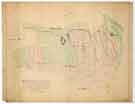
![View: arc03888 Crimicar Lane, Sheffield: Fields [1791]](https://www.picturesheffield.com/imagefiles/jpgs_sheffield3//arc03888.jpg)
![View: arc04065 Broomhall Street. The Burgesses land between West Street and the Moor (Blacklands, Lee Close), [1793], [1816]](https://www.picturesheffield.com/imagefiles/jpgs_sheffield3//arc04065.jpg)
![View: arc03889 Upper Hallam Inclosure: Burnt Stones and the Hag Common, [1791]](https://www.picturesheffield.com/imagefiles/jpgs_sheffield3//arc03889.jpg)
![View: arc03892 Upper Hallam Inclosure. Burnt Stones and Hag Common - allotments, [1792]](https://www.picturesheffield.com/imagefiles/jpgs_sheffield3//arc03892.jpg)
![View: arc04045 Marcus Street. Plan illustrating a dispute between John Middleton and the Sheffield and Manchester Railway, [1839]](https://www.picturesheffield.com/imagefiles/jpgs_sheffield3//arc04045.jpg)
![View: arc03891 Upper Hallam Inclosure. Outline of White Path Moss, [1792]](https://www.picturesheffield.com/imagefiles/jpgs_sheffield3//arc03891.jpg)
![View: arc03893 Stanage. The Upper Hallam High Moors showing the old and new boundaries between Sheffield and Stannington, [c. 1795-1801]](https://www.picturesheffield.com/imagefiles/jpgs_sheffield3//arc03893.jpg)
![View: arc03894 Stalker Lees Road. Revised boundary between Sheffield parish and Stannington, [1828]](https://www.picturesheffield.com/imagefiles/jpgs_sheffield3//arc03894.jpg)
;)
;)
;)
;)
;)
;)
;)
;)
;)
;)