Record Detail
Large format version available - click on Zoom button to browse this image in a zoomable viewer
| arc00462 | |
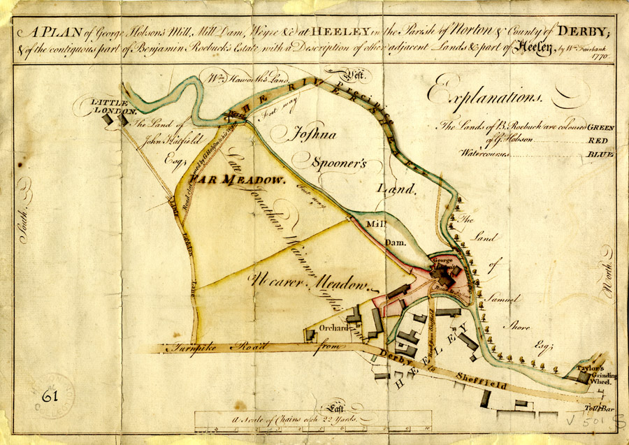
| A plan of George Hobson's mill, mill dam, weir, etc. at Heeley and of the contiguous parts of Benjamin Roebuck's estate with description of other adjacent lands and part of Heeley, by William Fairbank | |
| Sheffield_Heeley | |
| 1770 | |
| 1500-1799 | |
Shown on the map are the River Sheaf, Little London Lane, Far Meadow, Nearer Meadow, Taylor's Grinding Wheel, Turnpiek Road from Derby to Sheffield [Chesterfield Road], a toll bar [?Heeley Toll Bar at the bottom of Albert Road] and lands of Joshua Spooner, Samuel Shore, Jonathan Wainwright, Benjamin Roebuck and William Haworth. It is believed the present day location of this area is near to 300 Broadfield Road Park, Broadfield Road, S8 0XQ. Original at Sheffield Archives in the Hobson Collection (ref. HC/61). |
Copying and access
This digital image, and all images on Picture Sheffield, are protected by copyright. You may use it for private study or non-commercial research, with due acknowledgement.
You may share it on social media via a linked post or by citing www.picturesheffield.com together with the Image Reference, unless its copyright is noted as belonging to another organisation. You must not reproduce it by any other means without permission.