Record Detail
Large format version available - click on Zoom button to browse this image in a zoomable viewer
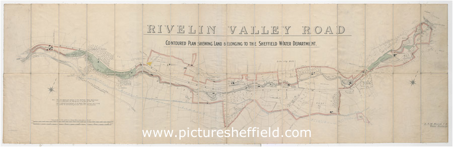
| arc02953 | |
| Contoured plan of Rivelin Valley Road showing land belonging to the Sheffield Water Department | |
| Sheffield_Rivelin | |
| 1900-1919 | |
Scale 25 inches : 1 mile. Surveyor: L. M. S. Marsh, Water Engineer. Lithographers: Pawson and Brailsford. 'The line edged pink belongs to the Sheffield Water Department and is available for laying out in building sites, etc. That coloured blue [actually green on the map?] belongs to the Water Department but is only available for recreation grounds and similar purposes.' From Rivelin Mill Bridge in the west to Holme Lane Bridge in the east. Reading left to right: Rivelin Mill Bridge Mill Dam Rivelin mills Rails Road Upper Coppice Wheel Lower Coppice Wheel Rivelin Wire Mill The Coppice Coppice Farm Manchester Road Coppice Wood Rivelin Glen Low Coppice House Paper mill Coppice House Wolf Wheel Tofts Lane Oak Farm Under Tofts Rivelin Hotel Hagg Lane Cottages Iron Wheel Glen House Glen Bridge Upper Cut Wheel Den Bank Plantation Hagg Lane New Wheel Little London Wheel Liberty HillHolme Head Wheel Allotment gardens Russel Wood Roscoe Plantation Roscoe Wheel Roscoe Bridge The Hagg Haggs House Reaps Wood Back Lane Spooner's Wheels Bole Hill Road Staney Wood Hollins Bridge Mill Holly Bush Inn St Michael's Mortuary Chapel / Roman Catholic Cemetery Hollins Bridge Rivelin Road Walkley Bank Tilt Mouse Hole Forge Walkley Bank Morley Street Holme Lane Bridge Malin Bridge Part of Holme Lane Part of Loxley New Road Annotated with Rivelin Conduit, 24 inch main, etc. Original at Sheffield City Archives: X109/1. |
Copying and access
This digital image, and all images on Picture Sheffield, are protected by copyright. You may use it for private study or non-commercial research, with due acknowledgement.
You may share it on social media via a linked post or by citing www.picturesheffield.com together with the Image Reference, unless its copyright is noted as belonging to another organisation. You must not reproduce it by any other means without permission.