Record Detail
Large format version available - click on Zoom button to browse this image in a zoomable viewer
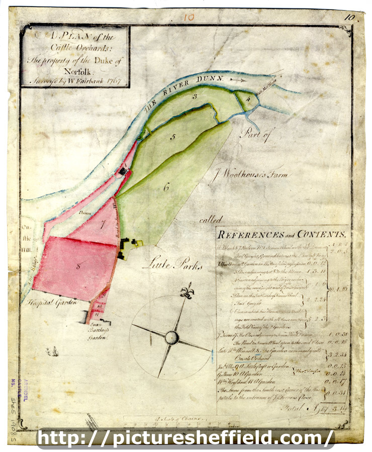
| arc03393 | |
| A plan of the Castle Orchards: The property of the Duke of Norfolk | |
| Sheffield_City_Centre | |
| 1767 | |
| 1500-1799 | |
Scale 3 chains : 1 inch [26.6 inches : 1 mile]. Surveyor: William Fairbank II. The land from the Hospital Garden to the Walk Mill Weir, including the old Simon Wheel and Dam; numerical list with tenants, field names and descriptions and acreages. Park Furnace and the Simon Wheel (the works on the south side of the River Don from the junction with the Sheaf to modern Leveson Street) Furnival Road / Victoria Station Road. Parchment. [F. B. 32, pp. 22-23] B, p. 34. Dimensions: 28.5 x 35 cm. Original at Sheffield City Archives: ACM/MAPS/SheS/1908s. Digitised with financial support from Sheffield and District Family History Society in memory of Professor David Hey (1938-2016) founder and life president of the Society. |
Copying and access
This digital image, and all images on Picture Sheffield, are protected by copyright. You may use it for private study or non-commercial research, with due acknowledgement.
You may share it on social media via a linked post or by citing www.picturesheffield.com together with the Image Reference, unless its copyright is noted as belonging to another organisation. You must not reproduce it by any other means without permission.