Record Detail
Large format version available - click on Zoom button to browse this image in a zoomable viewer
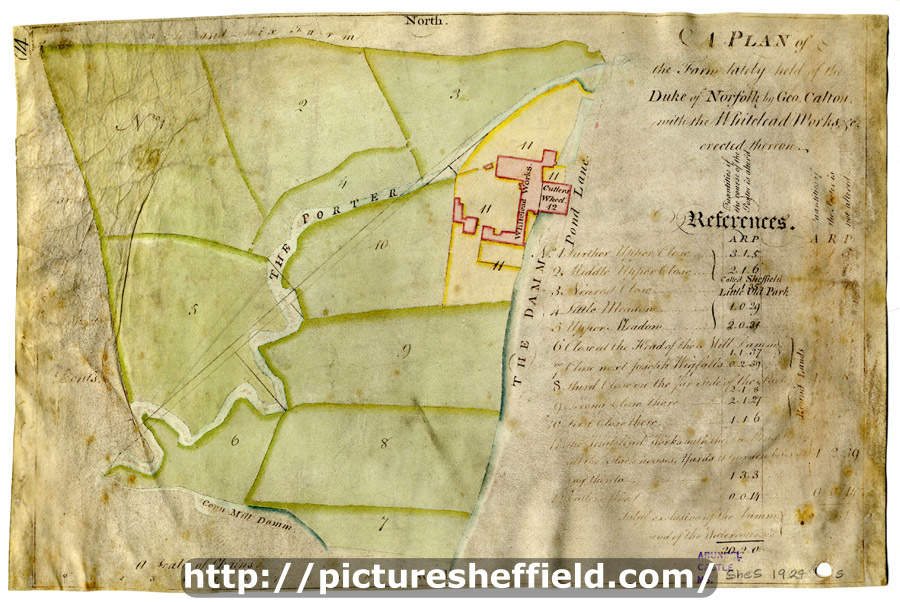
| arc03404 | |
| A plan of the Farm lately held of the Duke of Norfolk by Geo. Calton, with the Whitelead Works, etc. erected thereon | |
| Sheffield_City_Centre | |
| 1800-1850 | |
Scale 2 chains : 1 inch [40 inches : 1mile] Surveyor: [William Fairbank II]. Fields between the Porter and the Coach-and-Six Farm and between the White Lead Works and the Corn Mill dam; Lead works and Cutler's Wheel clearly marked; numerical list with field names and descriptions and acreages; Proposed new course of the River Porter added, with new acreages listed. Dated from rentals. Coloured, on parchment. (Shoreham Street, Arundel Street, Brown Street, Furnival Street, White Lead Works, Leadmill Road, Leadmill Street, Matilda Lane, Matilda Street, Pond Street (south end), St Mary's Road) White Lead Works and the fields between the Porter and the Sheaf, on either side of (modern Leadmill Road) B, p. 57. Dimensions: 35 x 23 cm. Original at Sheffield City Archives: ACM/MAPS/SheS/1924s. Digitised with financial support from Sheffield and District Family History Society in memory of Professor David Hey (1938-2016) founder and life president of the Society. |
Copying and access
This digital image, and all images on Picture Sheffield, are protected by copyright. You may use it for private study or non-commercial research, with due acknowledgement.
You may share it on social media via a linked post or by citing www.picturesheffield.com together with the Image Reference, unless its copyright is noted as belonging to another organisation. You must not reproduce it by any other means without permission.