Record Detail
Large format version available - click on Zoom button to browse this image in a zoomable viewer
| arc03964 | |
| The estate of Samuel Shore in Upper Hallam | |
| Sheffield_Fulwood | |
| 1823 | |
| 1800-1850 | |
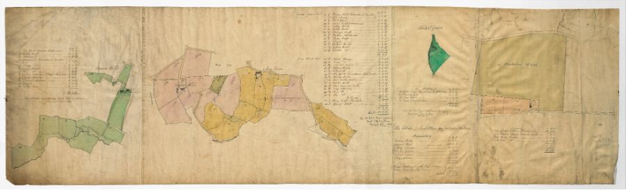
Scale 1/3 [inch] : 1 chain. Left to right: Brownhill (Far Croft and nearer Croft, Little Croft, allotment, Brownhills Homestead Garden Fold, House Field, Near Flatt, Far Fatt, Gerkin Meadow and Hizzle Hole, Park Meadow, Carnal Meadow, Pingle, Lodge Car). Bower Hill (Broomhead, Bower Hill homestead garden fold and green, stack yard, Tenter Croft and allotment, Nether Field, Lathe Field, Stringer Croft, Parkins Allotment, Stony Croft, pingle, Robins Field, Lesser Field, Greater Field, Upper Springs, Lower Springs, Middle Field, Upper Field, Calf Croft, May Green homestead, fold and garden, house field, Far Nether Field, Nether Field, Three Cornered Field, Long Meadow, Near Meadow, Har Meadow, Stony Croft Plantation, Springs Wood). Birks Green (Birks Green homestead, croft and garden, Smithy Croft, Daw Field, Lane and two gardens). Lodge Moor plantation, house, garden and small coft, near croft, far croft). Dimensions approx. 129 x 38 cm. Original at Sheffield City Archives: FC/P/Shed/379L Digitised with financial support from Sheffield and District Family History Society in memory of Professor David Hey (1938-2016) founder and life president of the Society. |
Copying and access
This digital image, and all images on Picture Sheffield, are protected by copyright. You may use it for private study or non-commercial research, with due acknowledgement.
You may share it on social media via a linked post or by citing www.picturesheffield.com together with the Image Reference, unless its copyright is noted as belonging to another organisation. You must not reproduce it by any other means without permission.