Record Detail
Large format version available - click on Zoom button to browse this image in a zoomable viewer
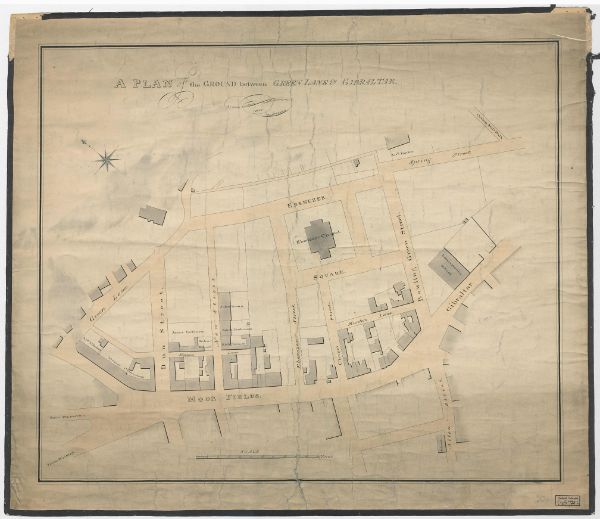
| arc04168 | |
| Moorfields. Plan of the ground between Green Lane and Gibraltar | |
| Sheffield_Netherthorpe | |
| 1824 | |
| 1800-1850 | |
By John Leather, land surveyor. Scale: 0.5 inch to 10 yards. Shows Green Lane, Dun Street, New Street [Dun Fields or Acorn Street], Ebenezer Square, Ebenezer Chapel, Bowling Green Street, Hunters Lane, Ebenezer Street, Spring Street, Cotton Mill Walk, Lancasterian School, Gibraltar, Chapel Street, Moor Fields [Moorfields], school, Allen Street, Holmes Lane. Owners / tenants marked: Abraham Ibbotson, Thomas Cornshaw, James Parkinson, Richard Holmes, John Brown, James Jenkinson, Richard Holmes, and Joshua Fowler. Dimensions approx. 68 x 59 cm Original at Sheffield City Archives: FC/P/SheS/721L. Digitised with financial support from Sheffield and District Family History Society in memory of Professor David Hey (1938-2016) founder and life president of the Society. |
Copying and access
This digital image, and all images on Picture Sheffield, are protected by copyright. You may use it for private study or non-commercial research, with due acknowledgement.
You may share it on social media via a linked post or by citing www.picturesheffield.com together with the Image Reference, unless its copyright is noted as belonging to another organisation. You must not reproduce it by any other means without permission.