Record Detail
Large format version available - click on Zoom button to browse this image in a zoomable viewer
| q00081 | |
| Ordnance Survey Map, sheet no. Yorkshire No. 294.8.12 | |
| Sheffield City Centre | |
| 1890 | |
| 1851-1899 | |
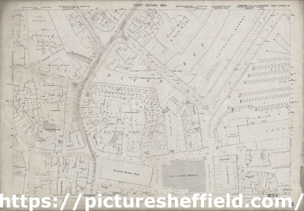
Surveyed in 1889. Reprint 1901. This map features: Top left: River Don, Blonk Goit, Wicker, Wire Works, Blonk Street, Water Lane, Castle Green, Waingate, Slaughter Houses, Mill Sands, Bridge Street, Tramway, Wicker, Gun Lane, Nursery Street, smithy, Mill Walk, [William Buckley and Co], Patent Piston Works on Millsands, [John Kenyon and Co Ltd], Mill Sands Steel Works, [Tennant Brothers Ltd], Exchange Brewery on Bridge Street, Town Mills (corn), Lion Hotel, Crown Inn, Great Gunn Public House, Wicker Brass Works, New White Lion Inn, Corner Pin Public House, Wicker Tilt (steel), Lady’s Bridge, Hare and Hounds Public House, Lady’s Bridge Hotel Public House, Chandler’s Row, Bull and Mouth Hotel Public House, Three Whitesmiths Public House, Bridge Inn, Anvil Inn, [W H Birks and Co.], Lady’s Bridge Brewery on Bridge Street, Wheat Sheaf Inn, Hollis Hospital and School. Top right: River Don, Blonk Goit, Wicker, Wire Works, Blonk Street, River Sheaf, [Samuel Osborn and Co], Clyde Steel and Iron Works, Smithfield Market (including pig pens and cattle pens), Smithfield Hotel Public House, Victoria Hotel Public House, Victoria Station Road, Park Station (Coal and Lime Depot), Manchester, Sheffield and Lincolnshire Railway, Maltravers Street, urinals, Blonk Bridge, [Seebohm and Dieckstahl Limited], Dannemora Steel Works (in margin), Furnival Road, Smithfield Hotel Public House, Alexandra Opera House. Bottom left: Water Lane, Castle Green, Waingate, Slaughter Houses, Castle Hill, Castle Folds Lane, Sheffield Castle (site of), Haymarket, Castle Street, Snig Hill, Angel Street, Bank Street, Dixon Lane, Town Hall, Norfolk Market Hall, Central Police Station, Royal Hotel, Rose and Crown Inn, New Market Inn, Rotherham House Public House, Norfolk Arms Public House, Rock Tavern, Tontine Hotel Public House, Brunswick Hotel Public House, Old No. 12 (s.v.), Black Rock Public House, Hen and Chickens Hotel Public House, Imperial Hotel, Castle Inn, Angel Inn, Old Queen’s Head Public House, Brunswick Hotel Public House, Royal Oak Public House, Wharncliffe Hotel. Bottom right: Slaughter houses, River Sheaf, Furnival Road, Exchange Place, Castle Folds, Exchange Lane, Wharf Street, Manor Yard, Castlefolds Market, Canal Warehouse, Canal Basin, Victoria Hotel Public House, Alexandra Hotel Public House, Canal Wharf, Smithy, Durham Ox Public House, Canal Bridge, Maunche Hotel, Corn Exchange, Golden Fleece Public House, Park Plate Works, Broad Street. Additional information from White's General and Commercial Directory of Sheffield, 1896 / Graces Guide. Surveyed 1889. Heliozincography 70/1901. Dimensions 77 x 102 cm. Scale 10.56 feet : 1 mile [1:500]. |
Copying and access
This digital image, and all images on Picture Sheffield, are protected by copyright. You may use it for private study or non-commercial research, with due acknowledgement.
You may share it on social media via a linked post or by citing www.picturesheffield.com together with the Image Reference, unless its copyright is noted as belonging to another organisation. You must not reproduce it by any other means without permission.