Record Detail
Large format version available - click on Zoom button to browse this image in a zoomable viewer
| q00082 | |
| Ordnance Survey Map, sheet no. Yorkshire No. 294.8.16 | |
| Sheffield City Centre | |
| 1890 | |
| 1851-1899 | |
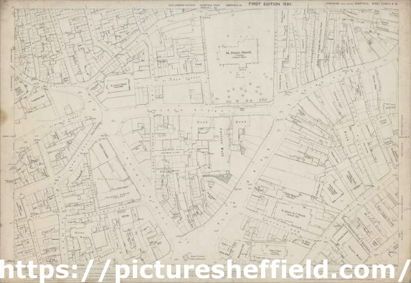
This map features Top left: Campo Lane, Church Street, St. James Row Bank, Trippet Lane, Pinfold Street, Bow Street, Canterbury Hall Public House, Orchard Street, Leopold Street, Sims Croft, School Croft, Hawley Croft, Lee Croft, Townhead Street, Vicar Lane, St. James Street, St. James’s Church, Golden Ball Public House, Church of England Institute, Vicarage, Burns Tavern, Townhead Street Baptist Chapel, and Temperance Hall on Townhead Street. Top right: Campo Lane, Church Street, St. James Row, Bank, Fargate, St. Peter’s Church, High Street, York Street, East Parade, Hawksworth Court, Aldine Court, Prior Court, Cutler’s Hall, Fargate, George Street, Mulberry Street, Bank, White Bear Public House, Parade Chambers, [Boys] Charity School on East Parade, Bank, Sheffield Daily Telegraph Office and Printing Works, Grey Horse Public House, Old Blue Bell Public House, Shades Vault Public House, Queen Victoria Hotel Public House, White Bear Public House, Waterloo Turf Tavern, Victoria Club, Police Institute, Hartshead, Watson’s Walk, Beeswing Tavern, Central Chambers, Star Hotel, Clarence Hotel, Printing Works, Athenaeum Club, Central Café, Thatched House Tavern, and York Chambers. Bottom left: Trippet Lane, Pinfold Street, Bow Street, Canterbury Hall Public House, Orchard Street, Leopold Street, Orchard Place, Museum Hotel Public House, Firth College, Holly Street, Holly Lane, West Street Lane, West Street, Sands Paviours, Carver Lane, Barker’s Pool, Exchange Gateway, Fleur-de-lis Hotel, Old Three Tuns Public House, Queen Victoria’s Jubilee Monument, Central School on Orchard Lane / Leopold Street, Playground, [Willliam Hall], Alma Works (files, edge tools, etc), [John Lucas and Sons], Queen Steel Works on Orchard Lane / Holly Street, Gordon Works (horn and ivory), [J. Bright and Co.], Livingstone Works (ivory) on Holly Street, Sheffield Institute for the Blind, Red Lion Hotel, Wharncliffe Arms Public House, Smithy, Crown Inn, Pool Square, Balm Green, Water Works Office, Inland Revenue Office, and cutlery handles manufactory. Bottom right: Exchange Gateway, Cutler’s Hall, Fargate, George Street, Mulberry Street Bank, White Bear Walk, Methodist Chapel (Wesleyan) on Norfolk Street [Norfolk Street Wesleyan Chapel], Nether Chapel (congregational), Vicarage, Sunday School, St. Marie’s R.C. Church, St. Marie’s Presbytery, Norfolk Row, Chapel Walk, Norfolk Street, Arundel Street, Sycamore Street, Tudor Street, Upper Chapel, Montgomery Hall, Surrey Street, Bank, Albany Hotel, Derby Works (engineering), Old Red House Public House, Green Dragon Hotel, Furnival Spirit Vaults, Assembly Rooms, Theatre Royal, [John Round and Son], Tudor Works (silver, nickel silver and electro plate), Tudor Street, [C. Smith and Sons, general tinplate workers], Arundel Works (tin plate), Cutlery Works, [Joseph Rodgers and Sons Ltd.], Rodgers Grinding Wheel (cutlery), Garrick Hotel, Alliance Chambers, Sheffield Gentlemen’s Club, Mulberry Tavern, and [?William Gallimore and Sons], Arundel Electro Spoon and Fork Works (on Arundel Street). Additional information from White's General and Commercial Directory of Sheffield, 1896 / Graces Guide. Surveyed 1889. Reprint '35/99'. Dimensions 77 x 102 cm. Scale 10.56 feet : 1 mile [1:500]. |
Copying and access
This digital image, and all images on Picture Sheffield, are protected by copyright. You may use it for private study or non-commercial research, with due acknowledgement.
You may share it on social media via a linked post or by citing www.picturesheffield.com together with the Image Reference, unless its copyright is noted as belonging to another organisation. You must not reproduce it by any other means without permission.