Record Detail
Large format version available - click on Zoom button to browse this image in a zoomable viewer
| y09563 | |
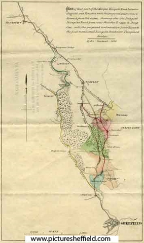
| Plan of that part of the Halifax Turnpike Road between Sheffield and Penistone by W. and J. Fairbank | |
| Sheffield | |
| 1825 | |
| 1800-1850 | |
| SCC | |
Plan of that part of the Halifax Turnpike Road between Sheffield and Peniston, with the proposed Diversions and Branch from the same: shewing also the Langset Turnpike Road from near Wadsley Bridge to Deep Car; with the proposed continuation from thence to the first mentioned Turnpike Road, near Thurgoland Bridge. Scale 2.6 inches : 3 miles. Size 42 x 34 cm. Original at Local Studies E5S. |
Copying and access
This digital image, and all images on Picture Sheffield, are protected by copyright. You may use it for private study or non-commercial research, with due acknowledgement.
You may share it on social media via a linked post or by citing www.picturesheffield.com together with the Image Reference, unless its copyright is noted as belonging to another organisation. You must not reproduce it by any other means without permission.